Page History
...
- GDF_GISOS_cavity_roof_geopolygon_3D

GNSS STATIONS
Data details
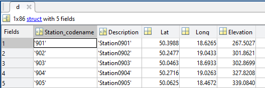
‘d’ structure contains fields:
- Station_codename– vector of char type specifying code name of the measurement device
- Lat– vector of real numbers specifying latitude of logger
- Long– vector of real numbers specifying longitude of logger
optional:
- Description– vector of char type specifying description of the logger
- Elevation– vector of real numbers containing elevation above sea level of the logger
- Depth– vector of real numbers specifying depth of the logger
- Sensor_type– vector of char type specifying type or name of the logger
- Sample_rate– vector of char type specifying sample rate of the measurements
- Parameter_unit– vector of char type specifying measurements parameter information
- Start– vector of real numbers containing ‘matlab’ time of start operation of the logger
- End– vector of real numbers containing ‘matlab’ time of end operation of the logger
Field details
FieldDescription
- Station_codename– Code name of the station
- Lat– Latitude of the station
- Long– Longitude of the station
optional:
- Description– Description of the station
- Elevation– Elevation of the station
- Depth– Depth of the station
- Sensor_type– Type of the sensor
- Sample_rate– Sample rate
- Parameter_unit– Unit of the parameter
- Start– Start time of data recording
- End– End time of data recording
FieldType
- Station_codename– 3
- Lat– 124
- Long–134
optional:
- Description– 3
- Elevation– 134
- Depth– 114
- Sensor_type– 3
- Sample_rate– 3
- Parameter_unit– 3
- Start– 5
- End– 5
FieldUnit
- Station_codename– char
- Lat– deg
- Long– deg
optional:
- Description– char
- Elevation– m
- Depth– km
- Sensor_type– char
- Sample_rate– char
- Parameter_unit– char
- Start– datenum
- End– datenum
Files associated with format:
- GDF_MUSE1_GNSS_Stations.mat
GRAVITY MONITORING
Data details
...
Overview
Content Tools