Page History
...
GDF_EMILIA_ROMAGNA_oil_production_monthly [Oil Production]

PERIODIC GEODETIC MEASUREMENTS
Data details
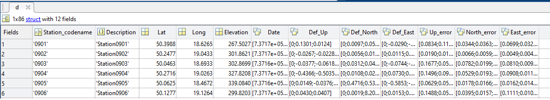
‘d’ structure contains fields:
- Station_codename– variable of char type specifying code name of the station/measurement point
- Date– vector of real numbers specifying ‘matlab’ time
- Lat– variable of real numbers specifying latitude of the station/measurement point
- Long– variable of real numbers specifying longitude of the station/measurement point
- Elevation– variable of real numbers containing elevation in meters above sea level of the station/measurement point
- Def_Up– vector containing geodetic measurements for each station/ measurement point
- Def_North– vector containing geodetic measurements for each station/ measurement point
- Def_East– vector containing geodetic measurements for each station/ measurement point
Optional:
- Description – variable of char type specifying description of the station/ measurement point
- Up_error– vector containing error in determining the coordinate ‘Up’ values
- North_error– vector containing error in determining the coordinate ‘North’ values
- East_error– vector containing error in determining the coordinate ‘East’ values
Field details
FieldDescription
- Station_codename– code name of the GNSS measurement device
- Date– time of measurement for each GNSS station
- Lat– latitude of the station/ measurement point
- Long– longitude of the station/ measurement point
- Elevation– height of each GNSS station/ measurement point
- Def_Up– vertical deformation for each station
- Def_North– horizontal deformation in „North” direction for each station
- Def_East– horizontal deformation in „East” direction for each station
Optional:
- Description – description of the GNSS measurement device
- Up_error– error in determining the coordinate „Up” in the topocentric system
- North_error– error in determining the coordinate „North” in the topocentric system
- East_error– error in determining the coordinate „East” in the topocentric system
FieldType
- Station_codename– 3
- Date– 5
- Lat– 124
- Long– 134
- Elevation– 32
- Def_Up– 114
- Def_North– 114
- Def_East– 114
Optional:
- Description – 3
- Up_error– 14
- North_error– 14
- East_error– 14
FieldUnit
- Station_codename– char
- Date– datenum
- Lat– deg
- Long– deg
- Elevation– m
- Def_Up– m
- Def_North– m
- Def_East– m
Optional:
- Description – char
- Up_error– m
- North_error– m
- East_error– m
Files associated with format:
- GDF_MUSE1_Deformation_Monitoring_System_GNSS_campaign.mat
PERIODIC GRAVIMETRIC MEASUREMENTS
Data details
...
Overview
Content Tools