Page History
...
- GDF_GISOS_NC_stations
- GDF_STARFISH_NC_stations
- GDF_TG_NC_stations
SHALLOW GROUNDWATER TEMPERATURE
Data details
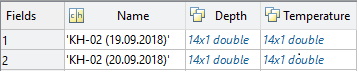
‘d’ structure contains fields:
- Name– vector of char type specifying name of the well where the measurement took place
- Depth– array of real numbers containing vectors of depth values
- Temperature– array of real numbers containing vectors of shallow groundwater temperature values
optional:
- Elevation – array of real numbers containing vectors of elevation values
Field details
FieldDescription
- Name – Code name of the well where the measurement took place
- Depth– Depth of the shallow groundwater temperature measurement
- Temperature– Shallow groundwater temperature
Optional:
- Elevation– Elevation in metres above sea level of the shallow groundwater temperature measurement
FieldType
- Name– 3
- Depth– 4
- Temperature– 22
optional:
- Elevation– 4
FieldUnit
- Name– char
- Depth– m
- Temperature– Celsius deg
optional:
- Elevation– m
Files associated with format:
- GFD_CARBFIX_shallow_groundwater_temperature_KH_02.mat
- GDF_CARBFIX_shallow_groundwater_temperature_KH_05.mat
SHALLOW VELOCITY PROFILE
Data details
...
Overview
Content Tools