Page History
...
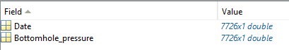
GDF_PREESEHALL_Bottomhole_Pressure [Bottomhole Pressure]
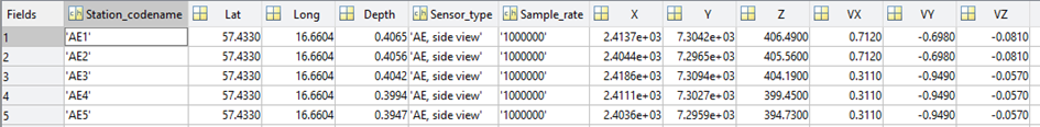
CARTESIAN STATION NETWORK
For specific networks, such as laboratory/underground-laboratory networks, the GDF file can be used to plot the station locations when cartesian coordinates (X, Y, Z) are provided instead of geographical coordinates.
Data details
‘d’ structure contains fields:
- Station_codename – vector of char type specifying code name of the station
- X – vector of real numbers containing local X coordinate of the station
- Y – vector of real numbers containing local Y coordinate of the station
- Z – vector of real numbers containing local Z coordinate of the station
optional:
- Description – vector of char type specifying description of the station
- Elevation – vector of real numbers containing elevation above sea level of the station
- Depth – vector of real numbers specifying depth of the station
- Sensor_type – vector of char type specifying type or name of the station
- Sample_rate – vector of char type specifying sample rate of the measurements
- Parameter_unit – vector of char type specifying measurements parameter information
- Start – vector of real numbers containing ‘matlab’ time of start operation of the station
- End – vector of real numbers containing ‘matlab’ time of end operation of the station
- VX – unit vector of sensor orientation in 3D space - X direction
- VY – unit vector of sensor orientation in 3D space - Y direction
- VZ – unit vector of sensor orientation in 3D space - Z direction
- Lat – real number specifying the latitude of the laboratory location
- Long – real number specifying the longitude of the laboratory location
Field details
FieldDescription
- Station_codename – Code name of the station
- X – vector of real numbers containing local X coordinate of the station
- Y – vector of real numbers containing local Y coordinate of the station
- Z – vector of real numbers containing local Z coordinate of the station
optional:
- Description – Description of the station
- Elevation – Elevation of the station
- Depth- Depth of the station
- Sensor_type – Type of the sensor
- Sample_rate – Sample rate
- Parameter_unit – Unit of the parameter
- Start – Start time of data recording
- End – End time of data recording
- VX – unit vector - X direction
- VY – unit vector - Y direction
- VZ – unit vector - Z direction
- Lat – real number specifying the latitude of the laboratory location
- Long - real number specifying the longitude of the laboratory location
FieldType
- Station_codename – 3
- X – 242
- Y – 242
- Z – 242
optional:
- Description – 3
- Elevation – 4
- Depth – 114
- Sensor_type – 3
- Sample_rate – 3
- Parameter_unit – 3
- Start – 5
- End – 5
- VX – 114
- VY – 114
- VZ – 114
- Lat – 124
- Long –134
FieldUnit
- Station_codename – char
- X – m
- Y – m
- Z – m
optional:
- Description – char
- Elevation – m
- Depth – km
- Sensor_type – char
- Sample_rate – char
- Parameter_unit – char
- Start – datenum
- End – datenum
- VX – unit vector
- VY – unit vector
- VZ – unit vector
- Lat – deg
- Long – deg
Files associated with format:
GDF_ASPO_Cartesian_Station_Network
CAVITY ROOF LEVEL
Data details
...
Overview
Content Tools